Group Rides
Links, Advocacy, & Contact
Flat Prevention Bike-Racers Email List
Advertise here (reasonable rates)
|
Calendar
Group Rides Links, Advocacy, & Contact |
MTB/CX
Trails
Road Routes Flat Prevention Bike-Racers Email List Advertise here (reasonable rates) |

There are a few websites that are
good for researching new trails. MTB
Project (a subsite of Alltrails.com) lists tons of trails,
but only ones that are "official trails." Open
Street Map and Google
Maps show a lot of trails as well.
The New Mexico Touring society also has some MTB trail info on
their Route Library page. Last
update 8/12/23.
Mountain Bike/Cyclocross/Gravel Trails, Listed by Area, Difficulty on 1-5 scale. NM towns and cities listed alphabetically, scroll down to your Town/Area. The Albuquerue info is pretty complete, as I live there and know most of the trails. The info for rest of the state is more of a summary with some links to local trail sites. Do you have a favorite trail/area that you would like listed? Email me . |
|
Albuquerque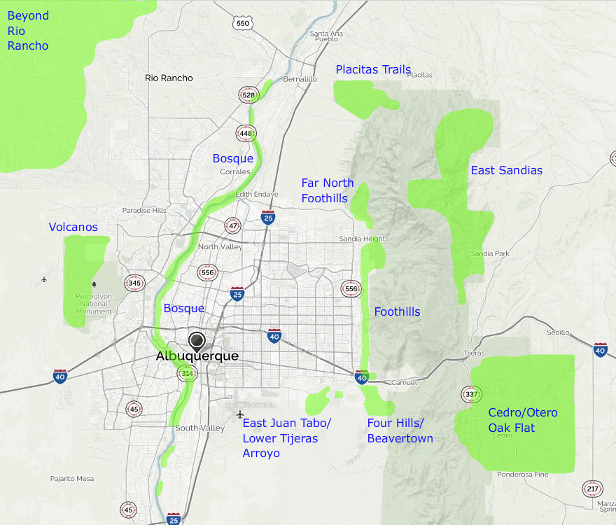 Cedro/Otero/Oak Flat: Kind of THE riding area in Albuquerque. Miles of trails famous, lovely trails which, like the East Sandias, are mostly hardpack with fixed or loose limestone rocks. Not a good area in the rain, as the hardpack turns to clay. Drier and lower altitude than the Sandias, forest is mostly juniper, pinon, and small oaks. The lower altitude Cedrlo trails are tend to be rockier. Note that most of this area is also open to motorcycles. Difficulty 3-5. There are a few easier trails around Oak Flat that are good for beginners or cyclocross/gravel bikes. Juan Thomas Rd and most of the doubletrack roads in the area are good on a CX/gravel bike. The Foothills (I-40 to the Tram): Singletrack on decomposed granite gravel, hardpack, fixed rocks, and coarse sand. System of maintained trails plus some infromal trails. Note: Bikes are not allowed above the wilderness fence. Heavily used area by bikes and pedestrians. Some folks ride their cross/gravel bikes on the smoother foothills trails. Difficulty: Generally 2-3, 4 on the trails closer to I-40. Most of the trails near the Elena Gallegos paved loop are good for Beginners. (1-2) Far North foothills (North of the Tram): There are a few trails off Forest oad 333, which leads up to the La Luz Trailhead. They are generally steep and rocky, wth some unrideablle sections. It is difficult to make a big loop in this area without a lot of portaging, but there are some cool out and back trails. All of the La Luz Trail is in wilderness and is closed to bikes. Difficulty: 3-5. Bosque ("Un Bosque" is Spanish for "a wood," and referes to all the undeveloped land adjacent to the Rio Grande): Huge network of mostly flat singletrack. Surface is mostly hardpack or sand. Most of it is good on a CX/gravel bike. Depending on the area and recent rainfall, some of the sand can be too soft to ride. The easiest trails are in the vicinity of Central Av. on the east side. If it gets too sandy, there is almost always a gravel levee road between the houses and the bosque. Sometimes there is a paved bikepath as well. East Sandias: There are tons of forest trails in the Sandias, thorugh the pines and aspens. The western slopes are wilderness, but most of the east slope is open to bikes. Trails are mostly hardpack, intersperced with fixed or loose limestone rocks. There is a bit of granite too, and a red shale-like rock. There is hadly a single flat trail in this area, always up or down. Not a great beginner area. Difficulty 3-5. Main parking/access areas are shown on the map. Not generally good on a CX/gravel bike. Placitas Trails: A network of trails on the north side of the Sandias. The western trails out on the prairie are good for beginners, mostly hardback with a few rocks. The eastern trails are more difficult. Surface is varied, hardpack, rocks, sand, and some cool red dirt. Bobsled trail is famous. Difficulty 1-4. (maps) The main road loop is good on a CX/gravel bike. There are also some other good hilly gravel roads in the area. Four Hills/Beavertown area. Description: This is a lesser known network of trails east and notheast of the Four Hills Neighborhood, in the winter when the trails are firmer you can ride from the Tijeras Creek most of the way to the two small mountains to the east of Four Hills via the "Terminator" climb. There are allso some woodsy trails by the creek and a neat trail that circumnavigates one of the smaller hills. Difficulty 3-5. Better on a MTB. Volcanos: Bicycles ae no longer allowed on the tails up to the volcanos, only on the crusher fine trail that winds in and out of the park around the mesa top above Boca Negra Canyon East Juan Tabo area: There is a 1/2 mile square of Open Space land with a few trails. There used to be lots of twisty trails out in the desert, but most have been razed to build the new houses. There are still a some twisty trails in the valley floor. Be aware that some of the valley area is private land, and the line between public and private land is not always marked. Beyond Rio Rancho: There are endless dirt roads west and northwest of Rio Rancho, as well as some quad/moto trails, going all the way down to the Rio Puerco. Sections tend to be sandy. Some are good on a gravel bike. There are also some new trails in the area of the Maiposa Subdivision, which I have not expored. Difficulty 1-3. North Valley Bike Park. The county maintains a free dirt jump park on the west side of 2nd Street just north of Alameda. Golden Open Space is near Golden, NM, and is part of Albuquerque Open Space. Guiterrez Canyon Open Space is about half way between I-40 and the crest road on South NM 14. Some really nice trails, some is a little chunky. Trailhead is behind Rumor Brewing Co. Better on a MTB. Popular cyclocross practice parks map. Chama One can acces parts of the Continental Divide Trail east of Chama. It is technnical but the views are amazing. The northern acces requires venturing a bit into Colorado. Some Trails used for the Redneck Epic are shown on the NMES site. Cochiti Sadly, most of the great old Cochiti area rides are closed after the 2011 Las Conchas fire. Last I head the even the Dome Road is inaccessable from the south. You can ride down the Dome Road from the Valles Caldera. Cluodcroft There are lots of trails around town and at the ski area. See MTB Project or one of the other sites listed above. Clovis There is a moto/OHV area wirh a few trails accessed via Red Hawk park north of town. El Paso, TX Franklin Mountain State Park has a network of trails. It is north of town on the west side of the mountains. Farmington There are a lot of trails out where they have the Road Apple Rally Race. Gallup There are some nice desert trails near town where they used to do the Squash Blossom MTB race. There was a lot of trail construction in the early 2000s out there. There area also some trails at McGaffey south of town. Grants Info coming Jemez Mountains Info coming Las Cruces Cruces has a lot ot trails. Los Alamos Info coming Red River info coming Roswell There is an arroyo just south of the mall and extending to the east that has a few trails. There are some sandy sections and some goatheads, so sealant is a must. Silver City There is some beautiful riding in the Gila north of Silver City. I will try to post some info here when I get a chance. Santa Fe Please refer to the excellent database on the Santa Fe Conservation Trust's website. In addition to the primary trails, the town of Santa Fe full of little trails in the arroyos, which run here and there all trough town. You just have to kind of explore them out. The Broken Spoke bike shop has put up a site devoted to Santa Fe MTB trails: http://santafesingletrack.com. San Ysidoro (White Mesa) Scenic Famous trails at white mesa. Map and info are available on the BLMs website. There is also a "red mesa" on the other side of the highway that has some slickrock like areas. I have not ridden this myself. BLM calls it the San Ysidoro Trials Area. Socorro The Magdalena Mountains west of town have some nice riding, there is the vast Quebradas Backcountry east of town, and a few townie trails just north of the College. Map and more info here. Last updated 12/21/21  |
|
|
Calendar
Group Rides Links, Advocacy, & Contact |
MTB/CX
Trails
Road Routes Flat Prevention Bike-Racers Email List |